
The digital transformation of the mining industry has arrived, driven by the convergence of Earth Observation (EO) technologies and remote sensing data, cloud computing, and advanced Artificial Intelligence (AI). At the heart of this evolution, the consortium pioneered a new GIS application development approach which is based on the AI Knowledge Packs (AIKPs). This novel modular methodology aligns with GEO Knowledge Hub approach for creation and retention of the ‘know-how’ that simplifies creation of the complex computational workflows and brings actionable intelligence to the application’s users.
In the GoldenRAM project, AIKPs are not just another tech buzzword; they represent the effective method to bridge the human skill gap and efficiency when processing raw geospatial data and delivery of valuable strategic insights for decision-making in the exploration, monitoring, and sustainable management of critical raw materials. Below is an overview of the AIKPs under development and their intended applications.
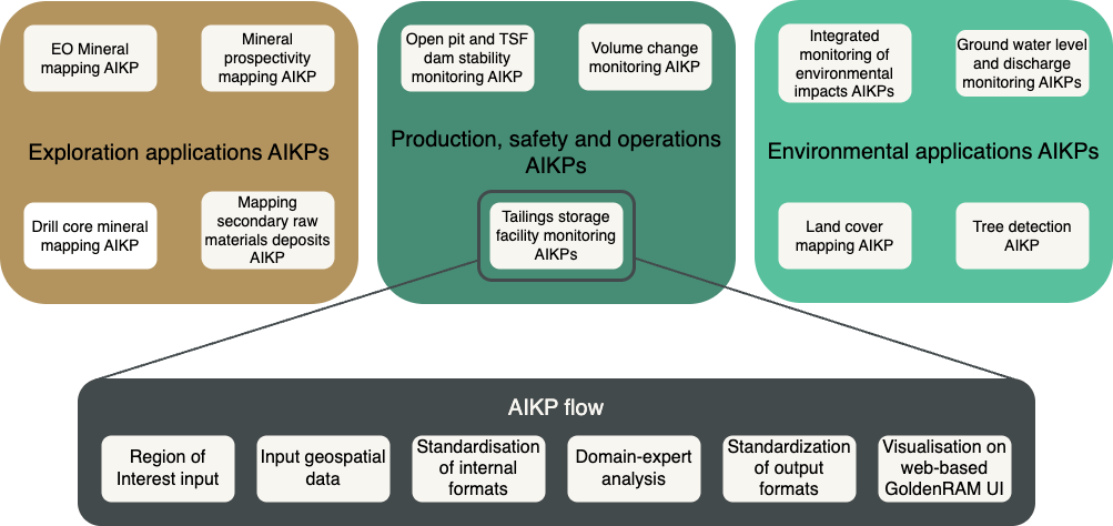
The GoldenRAM project AIKPs under development
What Are AIKPs?
AIKPs, or Artificial Intelligence Knowledge Packs, are essentially modular packages that combine multisource geospatial data inputs, advanced AI/ML algorithms, and curated domain expertise into standardised automated workflows. In the context of the GoldenRAM project, AIKPs can take as inputs the heterogeneous, multi-scale data from satellites, drones, and other remote sensing sources, process it using state-of-the-art machine learning and AI algorithms, and deliver outputs that industry stakeholders can easily visualise and interpret.
The Methodological Advantage
The beauty of AIKPs lies in their standardisations, modularity and scalability.
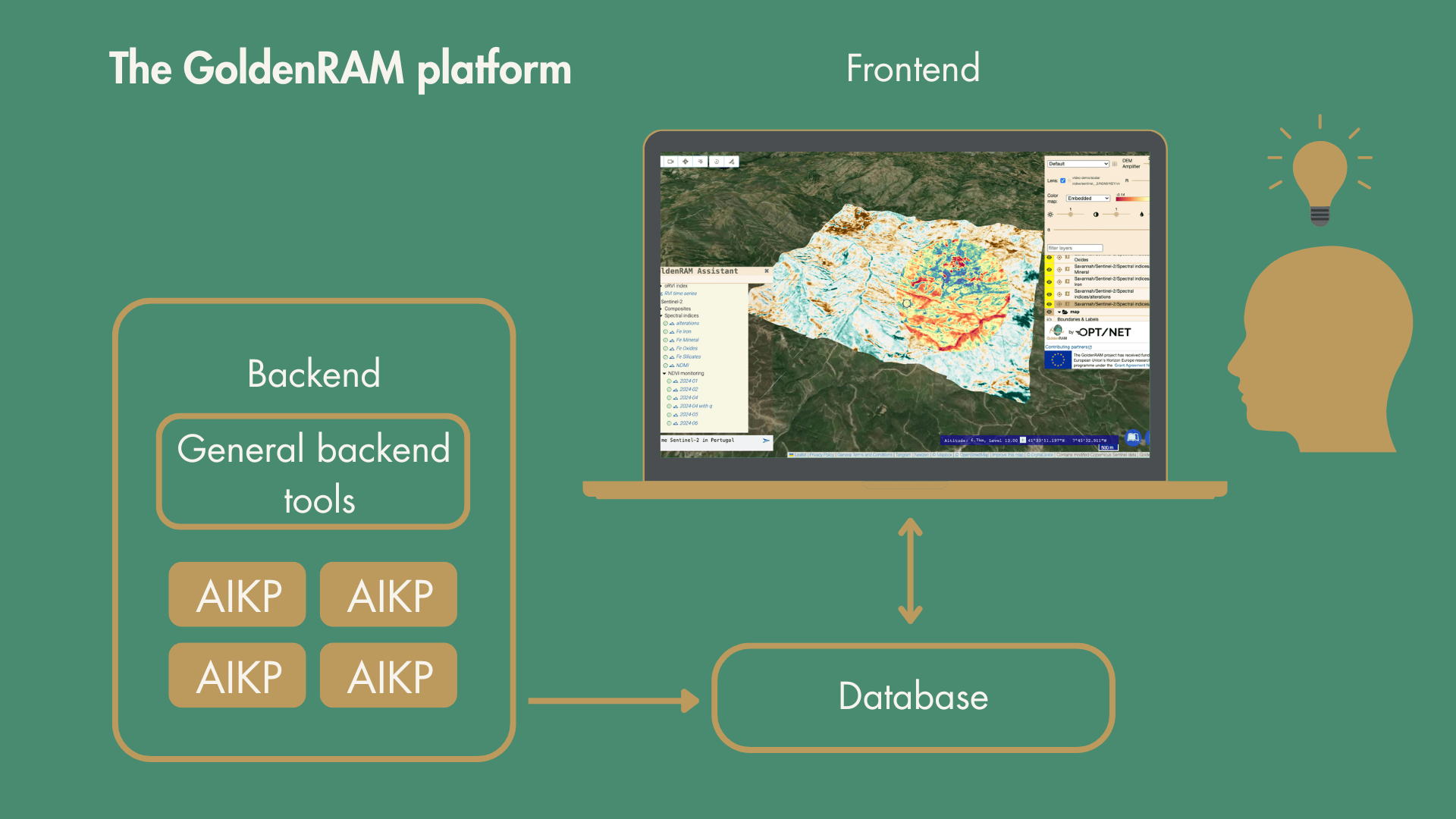
How the GoldenRAM platform works
AIKPs offer several key advantages for mining and geospatial applications.
Simplification of Complexity: Mining operations rely on diverse data sources, ranging from high-resolution satellite imagery to in-situ measurements. AIKPs streamline the acquisition and processing of these data streams by embedding domain-specific knowledge into automated workflows. This reduces manual interpretation and accelerates the transition from raw data to actionable insights.
Flexibility and Adaptability: Each AIKP functions as a modular component within the platform. It is possible to update, reuse, or adapt for different regions of interest without requiring redesign of the entire system. Multiple tasks can also run in parallel, supporting applications such as mineral exploration and environmental monitoring.
Enhanced Decision-Making: AIKPs integrate expert knowledge into standardised analytical workflows, enabling users without deep GIS expertise to generate reliable outputs. They support use cases such as mineral prospectivity mapping and slope stability monitoring, ensuring decisions are informed by consistent, data-driven insights.
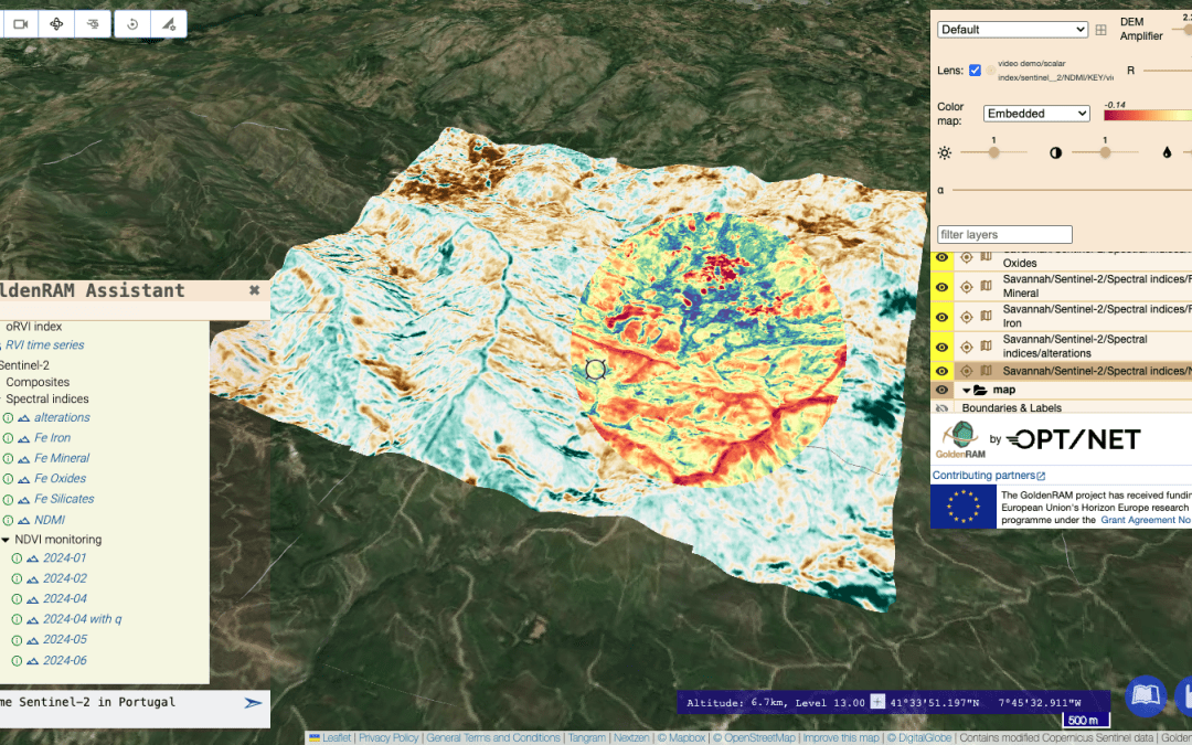
User-Friendly Interfaces: The GoldenRAM platform integrates natural language processing to enable intuitive interaction with AIKP outputs. Users can query datasets and results through human-readable commands in the web interface, simplifying access to complex geospatial products.
Bringing satellite intelligence and AIKP-powered analysis into a clean, intuitive UI – designed to support researchers, decision-makers, and environmental strategists
At a glance
By using a modular AIKP approach, the GoldenRAM project lays down best practices and standardisation protocols. This ensures that the innovative tools developed can be easily scaled or adapted to other regions and use cases within the mining industry and beyond.
Cover image: User friendly search for published datasets (output results of spectral indices AIKP based on Sentinel-2 optical images) with AI Assistant and Natural Language Queries on the GoldenRAM platform