In today’s day and age, the amount of data is growing exponentially. All that data is hard to collect and painful to analyse by human analysts. One of the main barriers is the high complexity of the acquisition, storage and processing of observational data, making its use and re-use in various commercial applications difficult.
To address the growing needs, with the help of integrated spatio-temporal Analysis Ready Datacubes (ARDs) and data fusion, one of the GoldenRAM project outputs is an advanced Earth Observation Platform to facilitate the exchange of accurate information on raw materials, enhancing exploration, extraction, and monitoring processes through AI-driven tools, geospatial data, and field trials across Europe, while supporting sustainability and compliance with the European Critical Raw Materials Act.
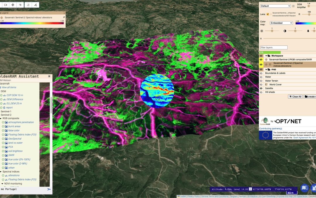
The GoldenRAM Web User Interface (UI) represents an interactive spatial data infrastructure, providing georeferenced cartography on local and regional scales through advanced data visualisation tools. Its overarching objective is to function as a comprehensive repository for Cloud Optimised GeoTIFF (COG) formatted data, ensuring easy exploration and exploitation by platform users. These datasets, available at different authentication and authorisation levels, foster interactive exploration with the assistance of a specialised natural language AI agent.
Led by OPT/NET, the GoldenRAM platform comes with new updates compared to its predecessor platform GoldenEye, namely the introduction of 3D visualisation capabilities. Since the GoldenRAM WebUI set up in the first months of the GoldenRAM project, access was granted to consortium members, along with interactive online workshops and the ongoing population of the data repository with derivatives of open-source remote sensing data, such as optical Sentinel-2 and ASTER and SAR Sentinel-1, for project field trials. These datasets are directly created through already developed and available AI Knowledge Packs (AIKP) for spectral indices, color composites, soil moisture estimations, etc. The data visualised in the video are real, based on optical Sentinel-2 imagery and reflecting the current state of the platform.
Major improvements have been made to provide project partners and AIKP developers with access to the platform’s backend, enabling them to begin working on project and user requirement goals. Their final analyses will be published and visualised in the GoldenRAM WebUI.
Interested to get a glimpse? Watch the video below.